Introducing FieldLink v7.0: Construction Made Easy
Trimble FieldLink delivers simple, impactful functionality that drives immediate value for users in the field and office alike. The features and enhancements in the latest release of FieldLink version 7.0 deliver improvements to a variety of workflows for prefabrication and in-field scan inspections, with easier information sharing between field and office.
What is FieldLink software?
At its core, FieldLink is a powerful tool that contractors use to accurately and easily translate designs from the office to the field, or to capture real conditions on site, analyze immediately in the field, and share back to the office to guide projects forward. By following purpose-built, construction-focused workflows, FieldLink makes data capture and working with 3D models in the field intuitive and easy.
FieldLink is built to help contractors get more out of their day by streamlining critical workflows, from construction layout to data capture. With 2D and 3D model support integrated into its foundation, FieldLink makes layout easy and efficient, reducing communication issues and helping field teams lay out directly from the design. For Quality Assurance (QA), it enables the capture of work in place and comparison against designs to validate construction quality using scanners or total stations. Additionally, FieldLink supports creating as-builts by capturing site conditions to report back to key stakeholders on current status, progress and completed work.
What’s New in FieldLink version 7.0?
In v7.0, we’re excited to add functionality that helps a wide range of users, while also adding specific capabilities to help enhance prefabrication workflows. We’ve made a range of enhancements that make project management much smoother and easier to navigate.
For scanning users, FieldLink’s differentiation comes from in-field productivity, so we’ve added more functionality to not only inspect your point clouds in the field, but to leverage the Trimble X9 3D laser scanner’s pointer to easily highlight areas of concern. In prefabrication scenarios, measurements must be relative to model dimensions and in FieldLink v7.0.
Improvements to scanning workflows
Aim Laser to Scan Point from Information Button and Auto Zero Floor Elevation for Scans provide significant benefits to concrete contractors, VDC coordinators, site engineers, field engineers and quantity surveyors. The Aim Laser to Scan Point feature allows users to directly target any point of interest within the point cloud with the instrument's laser, enhancing rapid in-field decision-making. This is achieved by enabling quick capture and inspection, and immediate addressing of areas of concern, which is crucial for tasks such as concrete setting and identifying design deviations.
Meanwhile, the Auto Zero Floor Elevation feature allows users to set the floor as the zero elevation during scans, ensuring scan data elevations are accurate relative to the true floor. This reduces the need for post-processing and adjustments, leading to high-quality and accurate construction outcomes by providing precise elevation heat maps and surface reports.
Aim Laser to Scan Point

Auto Zero Floor Elevation for Scans
Improvements for layout workflows
The 3D Model Transformations and Retain Station Setup Between Jobs features introduced in this release are designed to enhance accuracy, reliability and efficiency in construction workflows.
The 3D Model Transformations feature allows users to easily scale and rotate models in three dimensions to match coordinate systems accurately. This benefits prefabrication production managers and various contractors (steel, sheet metal, electrical, mechanical and plumbing) by ensuring precise dimension confirmation on the shop floor, reducing errors and improving efficiency for complex components.
The Retain Station Setup Between Jobs feature allows users to keep their total station, GNSS receiver and scanning setup intact when moving between layout jobs within the same project. This benefits layout technicians, field and site engineers and quantity surveyors by saving time, reducing redundant tasks, and streamlining project management and data organization between the field and office.
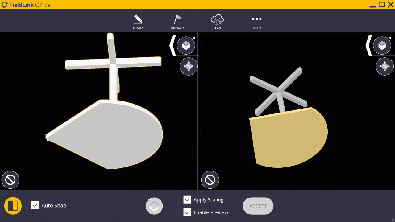
3D Model Transformations

Retain Station Setup Between Jobs
Additional Hardware Support
FieldLink 7.0 introduces new hardware features to enhance connection range, stability, and precision. The new Ri Bluetooth support allows users to extend their Ri device range up to 300 meters (984 feet) with external Bluetooth dongles like the Parani-UD100, addressing connectivity issues and boosting productivity for layout technicians, site and field engineers, and quantity surveyors.
Additionally, FieldLink v7.0 supports the updated R780-2 GNSS receiver with a dual-frequency smart radio antenna, offering job site flexibility with 450 or 900 MHz configurations. Trimble CenterPoint® RTX corrections are also included for the first 12 months, enhancing field precision and efficiency.
Upgrade Today
With FieldLink 7.0, we continue to push the boundaries of what's possible in construction technology. The new features and enhancements make it easier for users to manage their workflows, from design to execution, with unparalleled accuracy and efficiency. Contact your local dealer to upgrade to FieldLink 7.0 today and experience the future of construction collaboration.